Paid parking zones in close-up – data analytics as a tool for optimizing urban space
Contents:
– Paid parking zones – optimization
– CityScanner – data collection and analysis of the parking zone
– City data – the first step to better management of parking zones
The growing number of vehicles on city streets has contributed to a significant increase in the demand for parking spaces. To meet this challenge, many cities reach for the simplest solutions – by building additional spaces for paid city parking lots. However, a much better solution is to optimize the existing parking systems, improve the pricing policy or change the regulations on fees and their enforcement. To plan an effective parking management strategy, cites need detailed data that can be collected using advanced analytical tools, such as the CityScanner system. The Smart City concept – which modern cities are striving for – promotes the use of a data-driven approach to optimize parking infrastructure and improve urban mobility.
In many cities – and especially agglomerations – we observe increased traffic of passenger vehicles resulting from their growing number and the accompanying need to be mobile. The result is a constant surge in the demand for parking spaces, especially in the vicinity of city centers. In order to run errands downtown, road users usually try to get as close as possible to their destination, but finding a free parking space is an increasing challenge. The increasing time of searching for free parking spaces intensifies traffic congestion and generates unnecessary exhaust emissions, leading to deterioration of air quality in the city center.
The above circumstances are becoming a major challenge for local governments in the context of optimal planning of the availability of parking infrastructure, including the development of paid parking zones. The number and availability of parking spaces, their location and the amount of the fee affect the communication behavior of residents, visitors and tourists and affect the choice of means of transport. That is why many cities decide to look for solutions in modern information technology and implement advanced systems that fit into the Smart City concept. Their main task is to analyze traffic and provide data to better manage the presence of passenger vehicles in the centers.
Paid parking zones – optimization
It would seem that the simplest solution is to create more, larger paid parking zones, but it turns out that this is the least optimal solution. Rising prices of land, especially in city centers, make urban areas an exceptionally valuable and limited resource that should be developed in the most effective way, and renting free space for parking spaces is usually not beneficial usage. It is therefore worth starting an attempt to solve this problem by improving the functioning of the already operating zones. This can be achieved thanks to the appropriate planning of the service – pricing policy, subscriber rules or tight enforcement of fees.
However, in order to properly plan the parking space management process, detailed knowledge of the current situation and the demand for parking spaces is necessary. Dedicated analytical tools should be used to examine the situation on roads and car parks. They will allow to understand better the habits and behavior of drivers, provide valuable tips for further planning, setting the right rates or appropriate marking of parking spaces. In order for the entire system of paid parking lots to function optimally, it is also important to conduct cyclical analyses of the occupancy level of paid parking zones, real parking time and the study of the actual rotation of vehicles.
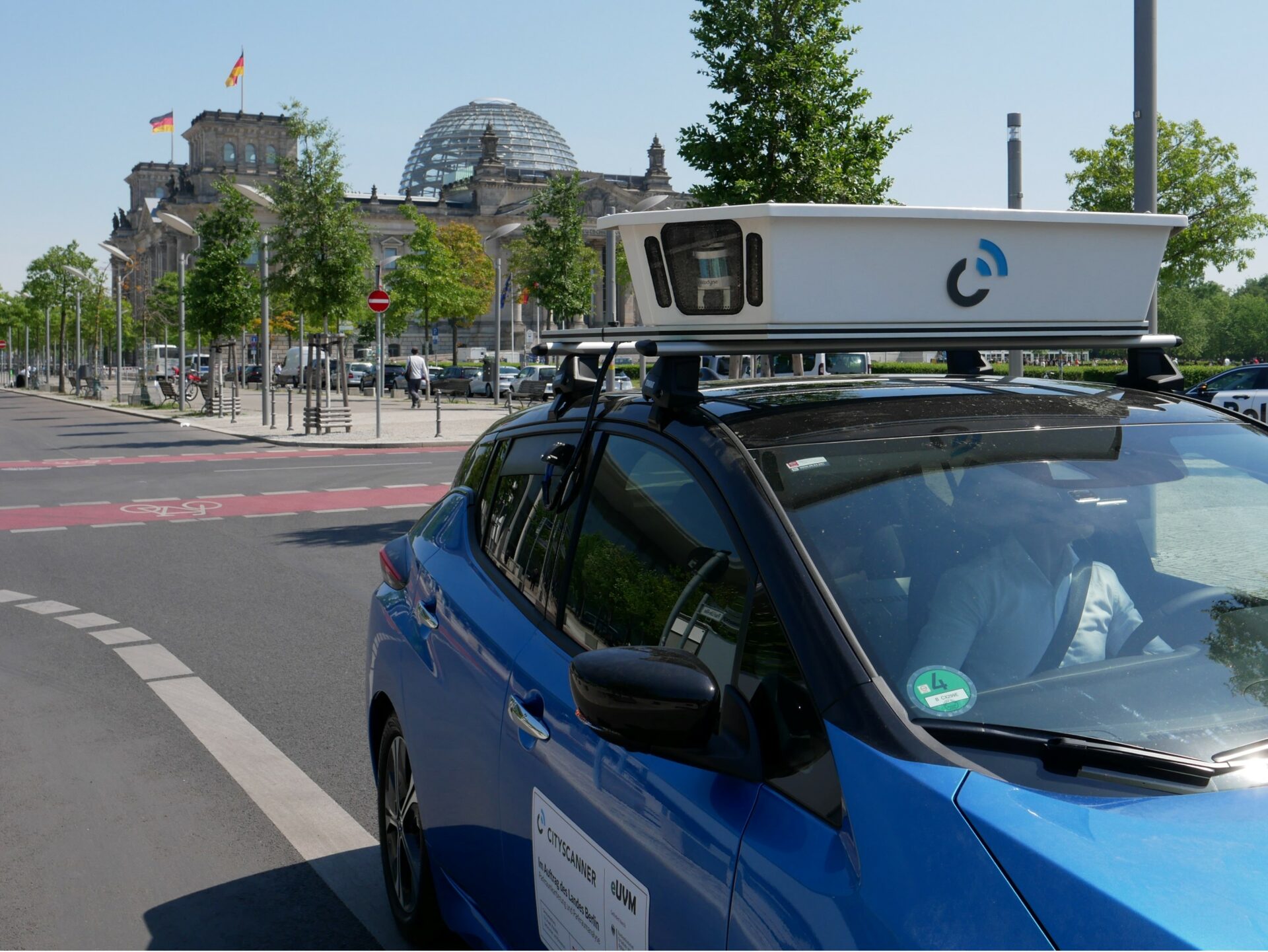
Modern cities usually start their activities by collecting as much data as possible, which, after being subjected to a deeper analysis, allows them to understand the behavior of traffic participants and make decisions regarding the organization of parking zones. The method of collecting data often depends on the city’s previous experience, but more and more often they use automated systems and services provided by specialized companies. One of such systems is the multisensor – CityScanner.
CityScanner – data collection and analysis of parking zones
The CityScanner system, which uses advanced image analysis technology and modern multisensors, allows for accurate mapping of areas occupied by cars and defining the legal status of each occupied place. Precise inventory of parking areas (i.e. polygons) is a basic element for collecting urban data. A fully automated license plate reading system enables accurate determination of the vehicle’s position and its presence in a designated area.
In order to be able to draw appropriate conclusions about the behavior of drivers and the functioning of parking zones, and on this basis to intervene in the current parking policy, it is necessary to collect as much information as possible. Periodic surveys carried out over a longer period of time allow to illustrate the actual state much better than random checking of the zone by ordering pedestrian censuses. Many cities have found out that “manual” research takes a long time, requires a lot of work, and is usually burdened with a large margin of error resulting from fatigue, low accuracy or haste of people carrying them out.
The advantage of automatic data collection using solutions such as CityScanner is the ability to collect thousands of data in a very short time. Video documentation (image from cameras) is always available for such information, and the operation of the device and the quality of the collected data are not affected by weather conditions, fatigue or time of day/night. Each drive collects detailed data on the exact position of vehicles remaining in the parking zone, their parking time, and – thanks to spatial analysis – it also checks which vehicles were inside and which outside the paid parking zone. Carrying out periodic, e.g. all-day analyses, allows e.g. to identify the ratio of short-term and long-term parking vehicles, learn about parking habits or the potential reason for parking in this particular place (work, shopping, residency, services).
City data – the first step to better management of parking zones
Collecting detailed data from urban parking zones is a very important stage of the whole process, but only a proper analysis of the collected information allows to understand the functioning mechanisms and is a real value for the city. The quality of these analyses depends primarily on the experience and expertise of the supplier performing them.
The result of a complete data collection and analysis process is, among other things, information enabling:
- Determination of the current demand for parking spaces (public/possibly private), which takes into account occupancy (also unacceptable/unpaid parking processes), recorded according to the time of day, duration of parking processes, frequency of turnover;
- Statistical analysis of out-of-town commuters by frequency and distance;
- Ratio of residents to commuters in built-up areas;
- Determination of the average distance from the selected point to an available parking space – this allows to determine the traffic in the center caused by the search for a parking space
- Determining the number of “dangerous” parking violations;
and in the case of long-term activities and a periodical evaluation process:
- Analysis of the impact of the pricing policy on the use of places;
- Analysis of the effects after the introduction of changes in parking space management.
This type of information, combined with recommendations issued by specialists, helps cities to adapt their parking policy so that it meets the needs of residents and guarantees the city an economically optimal way of using space in city centers.
The expectations of city dwellers in the 21st century are much greater towards managing institutions than those they had to face a dozen or so years ago. The pace of life is constantly increasing and the solutions used by cities also need to start working faster and more efficiently to keep up with their users. Only truly smart cities, by using the latest technological achievements in their decision making processes, will be able to meet the expectations of their residents and become cities friendly to everyone, including the motorized part – drivers.